330-476-6343 | [email protected]

330-476-6343 | [email protected]

By Carol McIntire
Editor
While many Carroll County residents were scurrying to the basement after a tornado warning was issued for Carroll County the afternoon of Aug. 12, John Storrie and his wife watched from upstairs as hail pelted all sides of their Sherrodsville area home and wind swirled around.
“We got the tornado warning on our phones, but due to medical reasons, my wife can’t make it down steps, so we had to sit it out upstairs,” Storrie said, sitting inside a John Deere skid steer four days after the storm wrecked havoc on two buildings on the family’s Orange Twp. farm.
“You know how they say when a tornado is coming, you can hear a train whistle? Well, I can’t hear so well, but my wife said she heard it. The wind started blowing and hail was hitting all sides of the house. It was blowing so hard you couldn’t see any of the buildings.”
When the storm passed, Storrie looked out the window and saw what he called “stuff” lying up against a semitrailer parked along the driveway to the grain and hay farm.
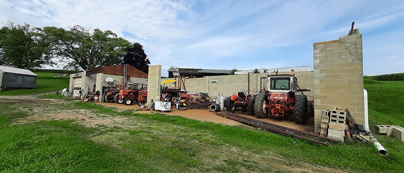
“I couldn’t make out what it was, so I looked at the machinery shed and shop and the roof was gone!”
The “stuff” Storrie saw lying against the semitrailer was the roof off the shed.
“It took about 80 feet of the 40×120 foot roof,” he said while assisting fellow crop farmers from Newcomerstown, neighbors and friends who are assisting with the cleanup. “The storm came from the west, but the roof was lying about 325 feet west of the building.”
The winds took the entire metal roof and all but about five trusses off the cement block structure, which allowed a steel roof beam to fall across two Allis Chalmer tractors.
The roof on a hay storage barn, located to the west of the shop, also sustained damage. Two semitrailers, located adjacent to the hay barn, remained upright and intact and corn in fields located close by, remained standing as if nothing happened.
The couple’s home, located across a driveway from the shop and shed, was undamaged.
Officials with the Carroll County Emergency Management Agency (EMA) visited the farm over the weekend and contacted the National Weather Service in Pittsburgh. National Weather officials visited the site Monday and ruled the damage was caused by a microburst with wind speed between 90 and 100 miles per hour. EMA officials said the microburst occurred between 4:30 and 5 p.m.
According to National Weather Service, a microbust is a localized column of sinking air (downdraft) within a thunderstorm and is usually less than or equal to 2.5 miles in diameter. The agency’s webpage states microbursts can cause extensive damage at the surface, and in some instances, can be life-threatening.
A microburst starts with the development of a thunderstorm and the water droplets/hailstones being suspended within the updraft. Sometimes an updraft is so strong it suspends large amounts of these droplets and hailstones in the upper portions of the thunderstorm. There are many factors that can lead to evaporational cooling (sinking air) and therefore weakening of the updraft. Once this occurs, it is no longer capable of holding the large core of rain/hail up in the thunderstorm. As a result, the core plummets to the ground. As it hits the ground it spreads out in all directions. The location in which the microburst first hits the ground experiences the highest winds and greatest damage.
Wind speeds in microbursts can reach up to 100 mph, or even higher, which is equivalent to an EF-1 tornado.
Storrie received approval to proceed with the cleanup from his insurance company, and has been joined by farmers, neighbors and friends every day since the microburst.
“I can’t thank them enough for all the help,” he said.
Interested in a monthl roundup of stories? Enter your email to be added to our mailing list.
